To date (23d April 2017):
AUV surveys completed: 13 dives (394 through 406), 540 km of bottom track, 100 square km mapped at 1 m resolution.
ROV dives completed - 14 dives, >150 km, 10.6 days at the seafloor, 201 samples (around 920 kg in total), and hundreds of thousands of photos in addition to the video.
- 5 ROV dives along the Roseau Fault Scarp
- 2 ROV dives on the Agoucha volcanoes completed
- 2 dives at Crawen volcano
- 1 dive at Colibri volcano
- 3 dives at Roseau volcano
- 1 Coche volcano
- 190 rock samples acquired with VICTOR, some recovered during 6 NASA elevator deployments
- 4 sediment cores acquired with VICTOR
- 1 Kullenberg sediment core acquired
- >230.000 seafloor photos for photomosaics
- >30 3D video surveys for terrain reconstruction
Victor: 126 km of track over 202h of bottom time
Victor Dive 665: Souffleur fault - ongoing
Victor Dive 664: Roseau Volcano and Coche volcano
Victor Dive 663: Roseau Fault Canyons and Coche volcano
Victor Dive 662: Roseau Volcano
Victor Dive 661: Colibri volcano
Victor Dives 659 & 660: Crawen volcano
Victor Dives 656 & 657: Agoucha volcanoes (sampling, observations)
Victor Dives 653, 654, 655 & 658: Roseau Fault surveyed (sampling, observations, 3D surveys, photomosaics, coring)
AsterX: >440 km of trackline
AsterX Dive 394: Roseau Volcano South, 40 km of trackline
AsterX Dive 394: Crawen volcano survey, 52 km of trackline
AsterX Dive 395: Agoucha volcano survey, 42 km of trackline
AsterX Dive 396: Soufleur fault survey, 53 km of trackline
AsterX Dive 397: Aborted
AsterX Dive 398: Retour to Crawen, 42 km of trackline
AsterX Dive 399: Colibri volcano, 45 km of trackline
AsterX Dive 400: Roseau Volcano, 65 km of trackline
AsterX Dive 401: NW of Roseau Fault - cut short due to multi beam computer failure
AsterX Dive 402: NW of Roseau Fault
AsterX Dive 403: Coche volcano
AsterX Dive 404: South Roseau volcano
AsterX Dive 405: South Roseau volcano
AsterX Dive 406: Redonde Faults
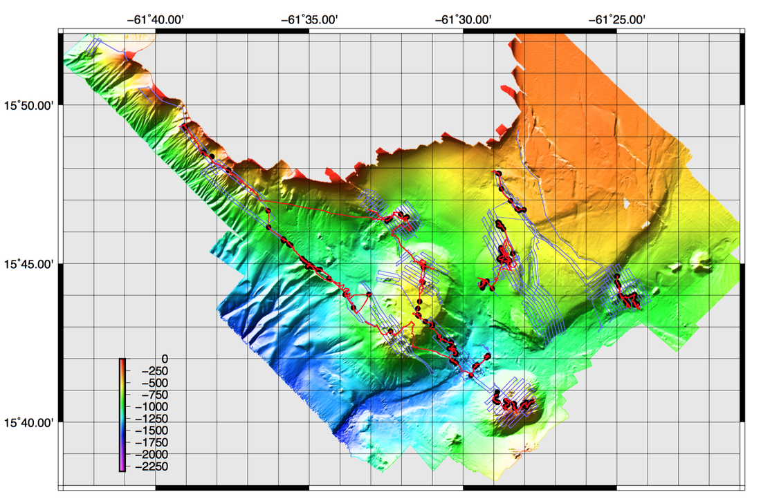
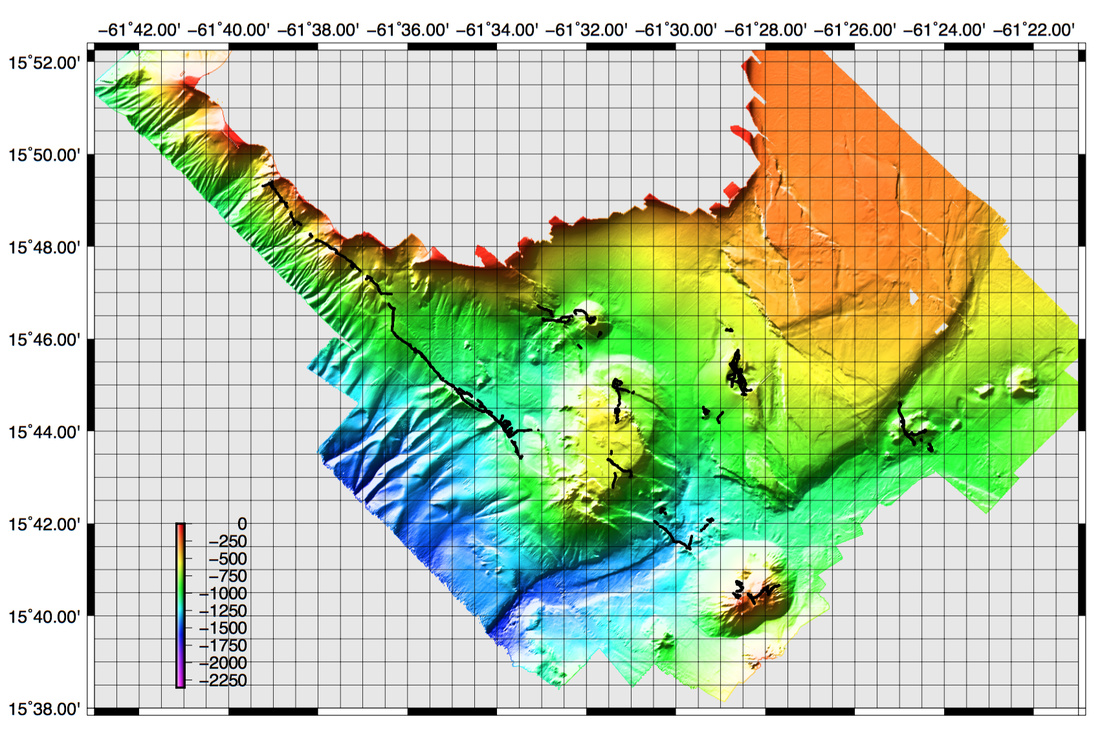
AUV map dives 394-406; Location map Red lines: ROV tracks dives 653 through 663; Blue lines: AUV tracks 394-404; Black dots: samples. The last map shows the location of OTUS images (>250000 photos) acquired during the ROV dives.
AUV surveys completed: 13 dives (394 through 406), 540 km of bottom track, 100 square km mapped at 1 m resolution.
ROV dives completed - 14 dives, >150 km, 10.6 days at the seafloor, 201 samples (around 920 kg in total), and hundreds of thousands of photos in addition to the video.
- 5 ROV dives along the Roseau Fault Scarp
- 2 ROV dives on the Agoucha volcanoes completed
- 2 dives at Crawen volcano
- 1 dive at Colibri volcano
- 3 dives at Roseau volcano
- 1 Coche volcano
- 190 rock samples acquired with VICTOR, some recovered during 6 NASA elevator deployments
- 4 sediment cores acquired with VICTOR
- 1 Kullenberg sediment core acquired
- >230.000 seafloor photos for photomosaics
- >30 3D video surveys for terrain reconstruction
Victor: 126 km of track over 202h of bottom time
Victor Dive 665: Souffleur fault - ongoing
Victor Dive 664: Roseau Volcano and Coche volcano
Victor Dive 663: Roseau Fault Canyons and Coche volcano
Victor Dive 662: Roseau Volcano
Victor Dive 661: Colibri volcano
Victor Dives 659 & 660: Crawen volcano
Victor Dives 656 & 657: Agoucha volcanoes (sampling, observations)
Victor Dives 653, 654, 655 & 658: Roseau Fault surveyed (sampling, observations, 3D surveys, photomosaics, coring)
AsterX: >440 km of trackline
AsterX Dive 394: Roseau Volcano South, 40 km of trackline
AsterX Dive 394: Crawen volcano survey, 52 km of trackline
AsterX Dive 395: Agoucha volcano survey, 42 km of trackline
AsterX Dive 396: Soufleur fault survey, 53 km of trackline
AsterX Dive 397: Aborted
AsterX Dive 398: Retour to Crawen, 42 km of trackline
AsterX Dive 399: Colibri volcano, 45 km of trackline
AsterX Dive 400: Roseau Volcano, 65 km of trackline
AsterX Dive 401: NW of Roseau Fault - cut short due to multi beam computer failure
AsterX Dive 402: NW of Roseau Fault
AsterX Dive 403: Coche volcano
AsterX Dive 404: South Roseau volcano
AsterX Dive 405: South Roseau volcano
AsterX Dive 406: Redonde Faults
AUV map dives 394-406; Location map Red lines: ROV tracks dives 653 through 663; Blue lines: AUV tracks 394-404; Black dots: samples. The last map shows the location of OTUS images (>250000 photos) acquired during the ROV dives.
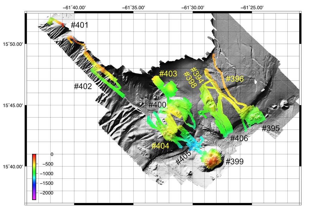
AUV AsterX microbathymetry and dive numbers